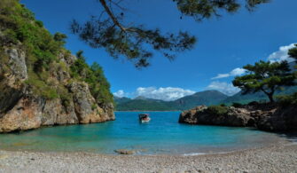
Covering the provinces of Muğla and Aydın, “Carian Way” is Turkey’s longest distance hiking trail with 800 kilometers in length. If you want to take a journey full of cultural, historical and natural beauties from the Mediterranean to the Aegean, from the past to the present, the Carian Way is just for you.
This trail, which consists of 4 main stages and an additional stage, will allow you to visit the attractive beaches, azure bays and ancient cities in Muğla and Aydın.
Carian Way, which was introduced to tourism in 2013, was created by combining ancient roads, pathways and forest roads. You can visit the historical cities on the trail and can hike, cycle, and surf along the Gulf of Gökova.
Information About Caria Region
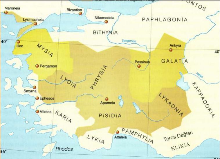
Caria is the ancient name of the southwest of Anatolia. It is the region between the south of the Menderes River and the Aegean Sea. Dalaman Stream forms the eastern border of the region. This region covers a large part of Aydın and Muğla Provinces and a small part of Denizli Province.
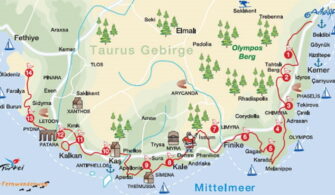
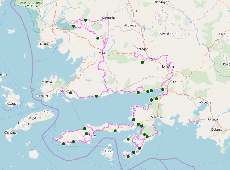
You can see the cities in Caria Region on the map below.

The region was named after the people named “Kar“ who lived in this region. Aphrodisias, Herakleia, Latmos, Knidos, Hierapolis, Iasos, Nysa, Stratonikeia, Alabanda, Alinda, Euromos, Gerga, Halicarnassus, Kedreai, Labraynda, Lagina, Laodikeia, Mylasa, Amos, Hydisos, Hyllarima, Phoiniks were the most important cities of Carian Region.
Stages of Carian Way
The Carian Way consists of 4 main stages and an additional stage.
1st Stage: Bozburun Peninsula
It starts in Icmeler Town of Marmaris District of Mugla Province and covers the Bozburun Peninsula and ends in Altinkum. In this step, you have the opportunity to see the unique beauties of the Bozburun Peninsula.
Trails in this area:
Icmeler – Turunc – Kumlubuk 11.1 km
Kumlubuk – Kizilcaogutmen – Bayir 14.1 km
Bayir – Bahceli – Taslica 18 km
Taslica – Karay Yuksek – Loryma 17.5 km
Loryma – Karamaka – Asardibi 11.5 mi
Asardibi – Republic – Bozburun 20.4
Bozburun – Selimiye 10.2
Selimiye – Bayır – Waterfall 17.9 km
Selale – Turgut – Hisaronu 20.3 km
Walking Routes
Click the links below for the coordinates of the walking routes in this stage.
Running Routes
Click the links below for the coordinates of the running routes in this stage.
Stage 2: Inner Caria
Starting from the Gulf of Gökova, this stage reaches to Bafa Lake after Milas (the ancient name of Mylasa), the old capital of Caria. Climbing from Bafa Lake to Beşparmak Mountains, this stage reaches the summit of Beşparmak Mountains and after Beşparmak Mountains, reaches Alinda, the city of Queen of Caria Island. This stage ends in Karpuzlu Town of Aydın Province.
Trails in this area:
1. Bozalan – Karacahisar
2. Karacahisar – Uyku Vadisi – Gökçeler
3. Gökçeler – Bahçe – Beçin
4. Beçin – Milas – Kırcağız
5. Kırcağız – Labranda – Kargıcak
6. Kargıcak – Ketendere – Çomakdağ
7. Çomakdağ – Kayabükü
8. Kayabükü – Karahayıt
9. Karahayıt – Kapıkırı
10. Kapıkırı – Kovanalan
11. Kovanalan – Bağarcık
12. Bağarcık – Yahşiler
13. Yahşiler – Karpuzlu
3rd Stage: Datca Peninsula
This stage starts from Old Datça and ends in Akyaka Town of Muğla. After Datça, Knidos Antique City and Deveboynu Lighthouse are located along the route.
Trails in this area:
1. Old Datça – Hızırşah – Domuzçukuru
2. (Alternatif Rota) Datça – Kargı – Domuzçukuru
3. Domuzçukuru – Hayıtbükü – Palamutbükü
4. Palamutbükü – Belen – Knidos
5. Knidos – Değirmenbükü – Mersincik
6. Mersincik – Yelimli – Körmen
7. Körmen – Kızlan – Eski Knidos
8. Old Knidos – Emecik
9. Emecik – Çakal
10. Çakal – Balıkaşıran
11. Balıkaşıran – Bördübet
12. Bördübet – Löngöz
13. Löngöz – Çamlı
14. Çamlı – Akyaka
Walking Routes
Click the links below for the coordinates of the walking routes in this stage.
Running Routes
Click the links below for the coordinates of the running routes in this stage.
4th Stage: Muğla and Surroundings
Starting from Akyaka, the route follows an old caravan route and passes through the ancient city of Thera to Muğla. This stage ends in the ancient city of Stratonikeia.
Trails in this area:
1. İçmeler – Turunç – Kumlubük 11.1 km
2. Kumlubük – Kızılcaöğütmen – Bayır 14.1 km
3. Bayır – Bahçeli – Taşlıca 18 km
4. Taşlıca – Karayüksek – Loryma 17.5 km
5. Loryma – Karamaka – Asardibi 18.5 km
6. Asardibi – Cumhuriyet – Bozburun 20.4
7. Bozburun – Selimiye 10.2
8. Selimiye – Bayır – Şelale 17.9 km
9. Şelale – Turgut – Hisarönü 20.3 km
Gulf of Gokova
Starting from Akyaka, the section reaches the Kıran Mountains through the forested paths and reaches the villages in the fertile valley. From above you can see the impressive views of the Gulf of Gökova and the mountains of the Datça peninsula. Part of the route passes through the old caravan roads that curl to reduce the slope.
1. Akyaka – Turnalı
2. Turnalı – Sarnıç
3. Sarnıç – Akbük
4. Akbük – Ören
5. Ören – Türkevleri – Bozalan
6. Bozalan – Gökbel – Çakıllıyalı
7. Çakıllıyalı – Kisebükü – Yalıçiftlik
8. Yalıçiftlik – Kızılağaç – Bodrum
Accommodation
There are pension / hotel-style businesses in many places along the Carian Way. In contrast, there are a few camping areas.
Timing (Which Season Trekking on the Carian Way?)
The best time for hiking is in the spring and autumn when the weather is cool. The summer months are very hot and humid for hiking.
Things to pay attention
Water resources are limited throughout the course. Therefore, in order to avoid water shortages, it is useful to have at least 2 liters of water with you when starting each section.
The red/white markings on the route will help you. Stay on course. It is recommended that you carry a device (GPS or smartphones) with which you can follow the coordinates.
Do not camp near water sources to avoid wild animals. Please note that these water resources are also used by wild animals.
There is plenty of pine trees and cones in the area, so you should not burn fire. Cones can catch fire very quickly and suddenly fire. If you need to light a fire, you should choose empty spaces without trees.
Please choose suitable shoes (trekking style hard soled ankle boots is recommended) and clothes for walking. When choosing coats, it is recommended that you prefer semi-permeable fabric coats that can throw your sweat out. Poncho-type raincoats are waterproof, but you sweat on walk and get wet from the inside. It is useful to have a large number of T-shirts for each day.
You should prefer pants (preferably shorts) that are quick-drying and designed for hiking. Jeans are definitely not recommended.
Sunglasses and a hat are a must.
It is helpful to have a small first aid kit with you.
If you are not an experienced hiker, it is not recommended to go for a walk alone. It is recommended that people who are not experienced enough to trekking with a team of at least three people.